Location, enroute to Walla Walla Regional Airport (KALW), Washington State: I’m leaving the town known as College Place, Washington, home of http://www.plr.org/ as well as Walla Walla College. The nearby city of Walla Walla is home to the more famous (locally) Whitman College and my nearest Starbuck’s! I drive very slowly down College Avenue, the speed limit is like 10 mph here and you don’t want to get roughed up by the school’s police force. It is a clear yet foggy morning in the Walla Walla valley, the air is cool, moist and clean smelling with a very slight hint of COW here and there. I watch the young-looking co-eds making their way around campus to classes…I can almost remember back to my own college days in Southern California. Something about West Coast College Campuses is always similar…but I digress.
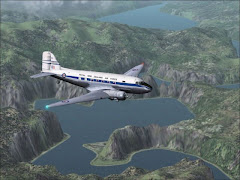
With my Decaf Grande’ Almond Mocha firmly in hand I continue the 15-minute drive to Walla Walla Regional Airport where my Horizon Air Dash-8 awaits in the warm morning sun. My first destination today is KTRR, known ‘round here as Lackey Ranch. With ATC’s direction I taxi out to runway 25 for departure. [ Photo 1 ] I climb up to a modest 13,000 feet heading direct to the Pendleton VOR. From the VOR I take a 209° heading towards Bend, OR, dialing in the DSD VOR for referance. [ Photo 2 ]
The first time I tried installing the scenery for KTRR I got a scenery file error message. The second time I got a computer crash. This third time (Peter has confirmed that the package works in FS2k2) I chose to ignore the error and drive on. I cross the DSD VOR and the DRAKE intersection and now am on the prowl for the “Lackey Ranch Airfield”. After taking the Dash 8 on several circuits of where I thought the place should be I open up the GPS (and subsequently some of the inner workings of FS) to discover that something is awry and I do NOT HAVE the required airport. Not wanting to abandon a FOTM in progress I head out on the 195 radial for 50.6 miles to Crescent Lake (5S2) a 3,760 foot dirt strip (13/31) at 4,810 feet ASL up in the Cascade Mountains – I figure this is as close to Lackey Ranch (both setting and size) as I’m going to get. It’s a bit tight around those big ‘ol pine trees, [ Photo 3 ] kinda like the August’04 FOTM, but with a little Slip-To-Land I plant the big twin down and get stopped with no problems. It’s now just a shade past 11 AM.
I pitched my tent, started a little fire there by the edge of the trees and phoned up Tony to confirm that I had arrived…somewhere. He gave me more explicit instructions for KTRR – repeating the instructions for the fourth time I again failed. Finally I get the combination to the little lock box and inside were my FOTM instructions. I tore into the envelope and read the directions for this FOTM…I had about 20 hours then to find an appropriate BizJet for the challenging airports listed. Those who have been around awhile know that I like to try and be a little bit different from the commonplace or obvious choices so I toyed around with taking the BAE146. I thought about a turboprop with the performance of a little jet. I wondered if I could download the little James Bond, single-seat jet I saw once. In fact, didn’t the Luftwaffe have some little rocket-planes? As I read on I saw that I’d have a limited list so…finally I decided on a plane that, frankly, looks kind of funny to me. This thing looks like another company tried to copy Bill Lear’s original idea of a light jet – but then they needed to upgrade the avionics and could only think of extending Pinocchio’s nose to do it! That first evening, with the plane loaded into the program (and another attempt at loading Lackey Ranch failed), I reconfigured the *.CFG to give me more than TWO lousy flaps options: I now had 5-10-15-30 and 45! Part of the challenge, according to Tony, was to fly the instruments; “By the Book” he had said. Well, it’s kinda tough to do that on a clear day (unless you’re going to tape a piece of paper over the top half of your monitor – hey! I should try that!!). So anyway, I set weather for the following:
no clouds
no wind
visibility only 3 miles under 10,000 feet Seems like that should make me use the published approaches!
no clouds
no wind
visibility only 3 miles under 10,000 feet Seems like that should make me use the published approaches!
I was a bit confident as last winter I started a Round the World Tour, hitting many of the dangerous airports along the way. At 06:45 AM the next morning I fired up the engines of the Club’s new little Cessna 550 Citation II and prepared for my one-day, whirlwind tour of the western US. In the first officer’s seat were all my favorite flight simming snacks: a box of Organic Peanut Butter Bumpers; a Costco-size canister of Roasted Peanuts; two boxes of chewy Trail-Mix Bars; a king sized bag of M&Ms; two Vanilla Cokes; some chilled rice-and-feta-stuffed grape leaves; a half-tray of Spanikopita; some cold snow peas; some raw Cauliflower and Red Peppers with Pesto-Ranch dip sauce and 2 gallons of drinking water. Winds were calm and I departed to the south. [ Photo 4 ]
With great care and concern I followed the recommended routings [ Photo 5 ] to Aspen taking the Carbondale NDB to the offset LOC. [ Photo 6 ] Actually, past experience has shown me that the LOC takes me about 2/3 of the way down the runway, so from the 344 NDB I fly a heading of 116 (rather than 120°). I mind my step- downs, fly deeper than my 11 mile/9,800 foot MAP taking her on down to 11.6 miles and 9,200 feet before seeing the runway ahead. [ Photo 7 ] I land a bit fast but get stopped easily in time to make a 2/3 turnoff shutting down at the pumps at 09:40.
With the vacationers loaded (and the cockpit cleaned of snack debris) I re-fire the engines at 10:20. I taxi out to the northeast end and depart back toward the NDB, climbing this time like the Space Shuttle [ Photo 8 ] rather than some simple business jet.
The flight to SantaFe is quick and quiet. [ Photo 9 ] There is a VOR and ILS there plus, no terrain to make things at all tough – so I do a coupled approach to runway 24 shutting down at the fuel station at 11:17 AM.
It takes until 12:43 to get everybody back on board and the 6-foot statue loaded. I taxi briskly back out to 2-4 and head for Sedona next. [ Photo 10 ] I fly to the Flagstaff VOR, take a south heading to Sedona, fly 12 miles outbound and pick up the inbound radial at 8,000 feet. I follow the plates step-downs diligently coming into the airport at mid-field…SHUCKS! I know that turning north is no option so I climb to 6,000 feet, fly over the airport and time one minute. I turn south for 90 seconds and commence a harder-than-standard-rate right turn back onto 033 degrees. [ Photo 11 ] Holding 5,800 feet now I spy the runway in under 20 seconds and make a dive for the lights. [ Photo 12 ] The landing is not smooth [ Photo 13 ] and at 125 knots I feel like I’m screaming in! But I am able to stop prior to the end and taxi over to fuel with shut down at 12:46.
With the passengers off-loaded I am now to wait for everyone else to arrive. Sounds like a good chance to try getting KTRR to work (perhaps that is that missing file Peter found in the recesses of his harddrive??) While I struggle to get things in working order the clock ticks on and I am unable to depart Sedona until 16:03 that afternoon. Having failed to get KTRR to load on the fifth or sixth attempt now I set off back to Crescent Lake. [ Photo 14 ] The scenery seems to change quickly from high-desert to the green forests of the cascades as I near Bend. Another failed attempt to load the add-ons (I’m feeling pretty incompetent by this point in time!!!) I pick up the outbound radial from DSD and head to 5S2 again. Once I can see the airstrip I turn left for downwind [ Photo 15 ] …I fly to the hillside before making a sharp turn to base [ Photo 16 ] …then line-up for final, making a better approach than in the Dash-8…Flare-and-float [ Photo 17 ] …It’s 17:48 and I’m feeling rather abandoned by my mates. I pack up the tent from the previous night’s stay, tidy up the area a bit and am ready to head out of the woods again by 18:30.
I turn the little Citation II around, hold the brakes and throttle up. Releasing the brakes I lurch ahead and take the roll beyond 120 knots before easing back on the stick. I feel really sorry for all the local wildlife but for my lack of a club airstrip I see no other choice. I fly over a couple NDBs on my way to a wet ILS into KPDX runway 28R. I come in across the Glenn Jackson Bridge, [ Photo 18 ] floating to a smooth landing [ Photo 19 ] before turning to GA parking and shutting down at 19:10.
I turn the little Citation II around, hold the brakes and throttle up. Releasing the brakes I lurch ahead and take the roll beyond 120 knots before easing back on the stick. I feel really sorry for all the local wildlife but for my lack of a club airstrip I see no other choice. I fly over a couple NDBs on my way to a wet ILS into KPDX runway 28R. I come in across the Glenn Jackson Bridge, [ Photo 18 ] floating to a smooth landing [ Photo 19 ] before turning to GA parking and shutting down at 19:10.
Tony, I’m glad this didn’t seem as tough as last August’s FOTM but darn-it, it would have a LOT more fun with Lackey Ranch! (Maybe someone with a functioning FS2002 could zip up the two folders for me?) Looking back on our FOTMs with add-ons seems to confirm what I always knew…I’m just lucky to get something other than default options working! Sorry, too bad for me.
Called Flounder for a Reason