As usual, I started this FOTM early. Hans had told me that we’d be heading to Africa…somewhere, and needless to say I was thrilled. You know, the default FS scenery here isn’t worth writing about – and I don’t do mesh on my old system. But for me, it’s the memories of Africa that are so special. So with that, I set out from where I ended the May flight…Portland, Oregon. In a recreation of my original flight, I left on a clear, breezy mid-May afternoon in a Boeing 707. We made a middle-of-the-night stop for gas in Newark, NJ before continuing on to London’s Heathrow airport. [ Pix 1 ]
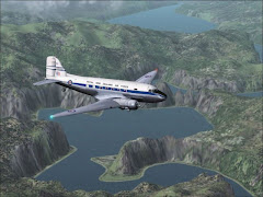
After spending a couple of days with Alastair, and visiting the soon-to-be-King of England, Prince William (Who needs Chuck anyway? Just skip him and move on to the better man!) Anyway, after a couple of days in Jolly Ol’ England I set off in a Douglas DC-8 stretch to Mombasa, Kenya. I figured this was pretty centrally located…it was by the beach (part of the Swahili Coast)…big enough airport to get me anywhere on the continent…and a generally nice place to hang out. The route down took me down the scenic west coast of Italy, [ Pix 2 ] a great flight despite a windy landing. [ Pix 3 ]
After a couple more days in Mombasa I heard that I could head to Johannesburg. I quickly secured an Air Tanzania 732 and departed that same afternoon. This was a windy, bumpy flight the whole way down. I kept requesting different cruise altitudes [ Pix 4 ] but they were all bumpy. I arrived into JoBurg just before 17:30. [ Pix 5 ]
What is the point, I wondered, of coming to a great continent such as Africa only to sit in a Big City? So the next morning I set out in a South African Express Jetstream41 for Livingstone, Zambia and Victoria Falls. [Pix 6 and 7 ] There I was free to hike the trail to the bottom of the gorge, take a safari cruise on the mighty Zambezi River [ Pix 8 ] or go on a jungle trek near the resort hotel. http://www.icon.co.za/~chundu/ So, that’s what I did! (I even included a link for Hans’ travel binder = great place to stay!!)
After feeling like I had FINALLY ARRIVED I received the actual FOTM details from our website. So, I was off to Cape Town. What a SPLENDID CITY!
THAT’S IT GUYS – if we should all arrange to meet someday we MUST meet up in Cape Town! BRILLIANT! That very night I left Livingstone, well after dark, in a flame-throwing F-105 Thunderchief. It was a gut-wrenching, high-G rocket ride to Port Elizabeth.
By 9 AM the next morning I was taxiing the Wideroe Dash-8 out to the active for an eastbound departure. My plan was simply this: To fly VFR down the coastline, around the Cape of Good Hope, looking for that Bed-and-Breakfast I stayed in over 30 years ago. From there…….
For awhile there I hand-flew the Alex Prolov “FANDA” [ Pix 9 ] plane despite its twitchiness. Just for reference sake I dialed in the Plettenburg NDB but then I decided to cell phone one of my Pastors from church who knows the area. Juggling the phone and the plane and the screenshots was not working so I set my Heading and 3,500 feet into the autopilot. Pastor Dave answered the phone with, “Hello Ron, have you made it to Cape Town yet?”
“Well,” I answered, “I’m on the way from Port Elizabeth, over some highway.”
“Great!” he replied. “The first major town will be Plettenburg, have you passed that as yet?”
“It’s just coming up now.”
“Okay, and right after that is a little berg called Sedgefield. My Father lives there! It’s about 5 and a-half hours to Cape Town from there.” [ Pix 10 ]
I could hear Dave’s wife in the background, “Is he on the N-2?”
Yes, apparently I was following the N-2 highway along the scenic coast, reminded me of California’s 101 south of San Clemente.
“The next town you’ll come to is George,” Pastor Dave continues, “it’s a bit larger than Sedgefield.” [ Pix 11 ]
His wife was in the background again, “Can he see the Outeniqua Mountains?”
At this point I was really anxious to continue but still needed to clear the Plettenburg NDB before dialing up George.
“After Mosselbaai and Overburg is Cape Agulhas” … “Up to Swellendam is wine country! Just to the north of there, up in the mountains, is where I used to go backpacking” So the next half-hour passed quickly. At Overburg I turned up to Swellendam, did a low-pass over the airport [ Pix 12 ] half expecting to see Peter out there on the tarmac holding a bottle of Zinfandel! Check out these two fun-sounding links:
From there I turned direct to the Greyton NDB. [ Pix 13 ] http://www.greyton.co.za/ My Cape Town DME now read 51 miles. I skirted over and between the Helderberg Mountain Range and could hear Dave telling me: "The Helderberg Mountain is named for the idea that it would at times stand out as a beacon above the fog or clouds in the Cape Flats (the area where the airport is situated). Hence, helder = clear and berg = mountain. Visibility around the airport can be very limited at times. Anyway, today it was just very bumpy! [ Pix 14 ]
There is a mountain which juts out westward from the north-south-running range, I followed low along that ridgeline [ Pix 15 ] to the town of Sommerset-West making a couple of VERY LOW passes over Helderberg College. (Hans, another link for you: http://www.hbc.ac.za/ ) I spent my weekend there 30-something years ago. [ Pix 16 ] Our Pastor Dave attended and later worked there and his son is there currently. Dave, I looked for him on the soccer field but I believe he was still in morning classes! (Small world huh?) Speaking of small worlds…it’s now time to include my link to Positive Life Radio, on the web at http://www.plr.org/ even available in South Africa!
Next, I turned back to the south to look for that Bed-and-Breakfast I stayed in oh so long ago. [ Pix 17 ] Where the little mountain range dwindles down into the sea east of M’nandi Beach, right on the base of the hills there, looking south toward the water was my room – great food too as I recall! [ Pix 18 ]
From there I turned back to the west, following the southern beaches toward the Cape Peninsula and Cape Point. [ Pix 19 ] This is home to one of the largest nature reserves in South Africa. After a couple of turns I headed back along side the peninsula and Table Mountain, known in Afrikaans as, Tafelberg. Hans, nice photo which you buried in your FOTM text [ Pix 20 ] Really, there is no lack of great photos from this place…maybe FS10 will have more realistic surface/city texturing and satellite plotting??? Anyway, on the day I took real weather the table cloth was drawn over – apparently unusual considering I was also showing winds out of 031 degrees. [ Pix 21 ]
I passed over the Newlands suburb [ Pix 22 ] before I dropped down over the seaboard and V&A Waterfront, complete with shops and ships. My next few passes were over infamous Robbin Island where the revolutionary Nelson Mandela was held for decades during the Apartheid movement. [ Pix 23 ] Huh…even a little grass strip there – I’ll have to check that out while I’m here. Having now spent most of the Dash-8’s fuel supply I headed back around the north end of Tafelberg [ Pix 24 ] for approach and landing to Cape Town’s runway 1. [ Pix 25 ] Again, I had winds out of 031 degrees gusting to 23 knots and this twitchy little Dash-8 was tough to bring down. I fought it all the way to the ground – used half the runway too [ Pix 26 ] but was then able to get parked and shut down without incident. Now, I needed to find some lunch and then I needed to figure a way I could stay with Pastor Dave’s son in the college dormitory.
Obviously I’m out of screenshots but I will tell you that during my weeks here in Cape Town I also flew a Sopwith Camel into Robbin Island, an RG into Fisanthekraal and took a couple spins in the Decathlon. Great fun was had by all!
Obviously I’m out of screenshots but I will tell you that during my weeks here in Cape Town I also flew a Sopwith Camel into Robbin Island, an RG into Fisanthekraal and took a couple spins in the Decathlon. Great fun was had by all!

Hans, this FOTM was like the original vision for these monthly features. Nicely written, nicely chosen, and nicely done. Really, we should all try and meet up here some November!! GREAT IDEA!