2011
Yes folks it's true, I had to fly this FOTM as soon as it
came in. It is one that in a matter of speaking I had already lived in the real
world. (pict1) and ( www.flightsim.com/main/feature/e13.htm ). I immediately made my
way to Burbank Airport and loaded up a batch of Hot and Gusty Santa Ana Winds
and a CDF S-2 Tracker Fire Bomber. (pict2) When I was
Fire Fighting in this area more than 25 years ago, the S-2s and B-26s were the
most common air bombers in use.
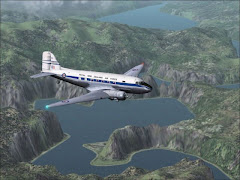
As instructed, I departed eastbound into the wind and then made a right-hand
turn quickly finding a visual on the 101 freeway westbound which passes to the
south of Van Nuys airport. (pict3) Having lived out at the west end of the 101 during
High School (FOTM November 2007) I could nearly name the LA County communities
below as I flew at 1,000 feet. As I approached Westlake Village I made the left
turn toward Zuma Canyon and spotted the road. (pict4) I followed
that low through the saddle and continued down in the canyon (pict5)and out over
the Pacific Ocean beaches that I still can remember clearly.
I made my second pass back up the canyon (pict6)(Turn the
speakers up baby!!) and then continued to climb on up to 2,000 feet for the
relatively short flight to Chino. (pict7)
Chino had its own Fire Department 25 years ago (pict8) and we
(Riverside County / CDF) ran some mutual aide with them on some bigger incidents
(like the fire along Highway 71 which is in Photo1 above). After 20
minutes on the ground to refuel and reload with slurry I departed southbound
(crosswind departure) and immediately followed the 71 south, (pict9) across the
91, and picked up the 215 which is very near to where my Fire Station is located
to this day. El Cerrito is a community along the 215 freeway just at the base of
the canyon of the same name and was covered by Riverside County Station 15 (now
part of Corona City, covered their by Station 7) – trust me, I know the area
well! (pict10)
I opened the Bombay doors and dove aggressively into the canyon,
(pict11) keeping at treetop height. As the canyon rose I
applied full throttles and climbed. . . . . . This climbing up the terrain is
certainly one of the most dangerous things!
In fact, I demonstrated the danger of cockiness by crashing into a
tree-covered ridge about two-thirds of the way up the canyon!!! (Very
embarrassing on this FOTM – in this location I know so well). (pict12)
Back to Chino:
I followed the same route down to El Cerrito Canyon, (pict13) this time making my runs a little safer, a little
more conservatively. (pict14) Rocketing up out of the canyon is really quite
the thrill I must say! (pict15) From nearly a mile high I dove back down the
steep eastern side of the mountain range making my drop and shooting out over
the local Golf Course. (pict16) (pict17) (pict18)
Next I flew past Lake Matthews (pict19)and beyond
March ARB, (pict20) up into the San Gorgonio Mountains, (pict21) near Lake
Hemet (pict22) and over Pine Springs Ranch (FOTM August 2010)
where I made some low passes. (pict23)
Finally I returned to the REAL Cal-Fire Air Base, the Hemet/Ryan Airport
where I followed a Caravan landing to the east. (pict24) What a
fun FOTM (despite my humiliation) – thanks to everyone for your participation. (pict25)
.
2013
With another summer blazing and two more years to wait for
this FOTM I decided to fly this feature again.
I repainted an A-3 Skywarrior in Cal-Fire/CDF themes and departed from Long
Beach airport. (pict26) I flew north intercepting the 101 freeway near
Van Nuys airport where I turned west. I was able to again find the location and
make my required low passes (this time painting in the water-drop effects)! (pict27) (pict28) (pict29) (pict30) (pict31) (pict32) I find
this model to be a bit "floaty" with flaps down, not the best thing for a Fire
Bomber. After successfully making two drops along Kanan-Dume Road I turned east
and headed for Chino Airport. (pict33) (pict34)
This time I switched aircraft into my repainted EMB-195; these modified AI
Aardvark models are very versitile! (pict35) I
departed again after about an hour and headed south along the same route I had
taken last year in the S-2. (pict36) I flew
south past El Cerrito Canyon (pict37) and then
made a big left-hand turn to line up for my first drop. (pict38) With
three notches of flaps in I set my autothrottle for 150 knots (pict39)and flew
down the canyon making the first drop successfully (pict40)and then
flying UP the mountainside safely! (pict41)
I turned about and headed back down the canyon (pict42) (this was
FUN!) making a spectacular water drop! (pict43) The
EMB-195 is obviously quite newer than the A-3 or S-2 and I had to deal with the
audible call-outs in this newer, advanced cockpit:
"Too Steep - Pull Up!"
"Terrain - Woop, Woop!"
"Minimums"
"Terrain - Woop, Woop!"
"Minimums"
"Pull Up!"
"Minimums"
(pict44)
Following directions, I flew to and landed at March ARB in Riverside. (pict45) (pict46)
.
Later in 2013
I guess I wasn't done yet! The call came in from one
of my facebook friends that there was a fire 200 miles to the north in the coast
range just west of Paso Robles. San Luis Obisbo County also contracts Fire
Protection Services from CDF so this was another call in the CalFire/CDF area! I
filled the water tanks on the 195 and headed that way. (pict47)
The location was immediately west of Oak Country Ranch airport so I took a
fly-by to get a lay of the land. (pict48) With that
info I slowed my speed, dropped in some flaps and made my run .... (pict49) (pict50)
After knocking down the flames (and protecting my friend's property) I landed
up at Paso Robles Airport. (pict51)
Just one more photo to share, from the El Cerrito Canyon fire. (pict52)
Too Much FS

Our Current, Newer Logo
Too Much FS

Our Original Logo
About Me

- Flounder
- I am a computer flight simulator enthusiast, a "Flight Simmer." "Simmers" use a flight simulation "game" such as Microsoft's Flight Simulator and pretend to fly various aircraft. The "game" is quite realistic actually, it includes cockpit procedures and real-world navigation as well as scenery and more than 24,000 airports covering the entire planet. For some users this is only a game, for a few it seems this is their life and for the rest of us, it's a HOBBY - and a great way to meet fellow aviation nuts. I along with a group of simming friends from around the globe host a virtual flying challenge each month at: www.toomuchfs.com. Please feel free to e-mail me for more information about our flight club or monthly feature flights on: www.toomuchfs.com
New Zealand's South Island
Caribbean Tours

Stormy Departure

Night Approach

South of Mumbai, India

Los Roques, Venezuela

Flight Club Airways is hosted on YahooGroups
Departing Phuket

Mumbai to Beirut

Rio, Brazil

Hazy Finals in Peru

Zurich back to Mumbai

Hot Rod out of Arequipa

Race to the runway!


