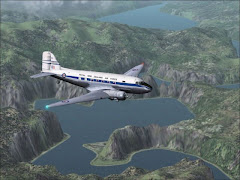
Truth be known, I’ve been holding onto this flight for 9 months, hoping to use it as a FOTM - it’s still an EXCELLENT flight and there’s lots to see!Come along, more or less, for a bit of a VFR sightseeing tour of our typical summer family vacation to Victoria, BC. I must tell you, both my wife and I loved our time in Europe; we cherish those memories and long for a time when we may get to return. (Lufthansa has daily non-stops, Portland to Frankfurt!) Well, for a lack of travel to Europe we go to British Columbia. We spent 10-days there on our honeymoon and try to get back at least once or twice a year. Of course, we drive 6 hours to the ferry, 90 minute crossing and another 40 minutes into Victoria. It’s great for even just a long weekend.This month we’re going to fly, and we’re going to start in Seattle (well, in the neighborhood anyway) and take an indirect, “look at the views out the window” kind of tour. It should be pretty easy and I’ll expect a lot of pictures! There are frequent flights in the summer from the Seattle/Bellevue area to Vancouver and/or to Victoria. We are going to make up our own route today, we’re going to fly under 3,000 ft so you can do LOTS of spot plane viewing of your aircraft and the outside world!I have included (I think) everything you need to get started. If you drop the Victoria.FLT, *.PLN and *.WX files into your “My Flights” folder, then select the Victoria flight, you should find yourself outside the Default Caravan Float on the southern tip of Lake Washington. (don’t linger too long or the breeze may blow you into the shore) Choose a new plane if you’d like and you’re ready to go!-See Picture One -The flightplan terminates at the Victoria International Airport but that’s NOT the end for us...we’re going to fly right into the inner harbor in Downtown Victoria! Now relax, they really do this (Depending on the weather it can be pretty hairy) but today will be no problems. This can provide for some really spectacular views of the Empress Hotel and the B.C. Parliament Buildings but those will likely not be in your sim.Note: I first flew this in FS2k but the newer version do have some Seattle-area float docks and you are welcomed to start from there and pick up the route along the way.Weather: I’ve included the *.WX file but if you prefer to write your own, it’s something like this:Clear skies, visibility 30-40 miles (that little sea-haze we get near the ocean)Winds = Out of the upper 200°S at about 5-7, gusting to 10-12.Temps = Daytime high 79°, Day/Night Variation 22°.Now, if you use Real-Weather that's fine too but you may end up coming in out of the west rather then the more challenging southward, with turn to the west (like Hong Kong in a float plane)Aircraft Used: I chose the Twin Otter Float but in real life they also use Caravans, Skywagons and Beavers. Now, I have a confession to make...I first set this up in December, 2002. Not knowing if this Flight of the Month Club was going to work out or not, I had two flights ready to send out to you guys. (This one and the Medford -> Portland -> Pendleton run) So, I did this in FS2000 in my own (unauthorized) paint job, West Coast Air colors. Once I updated to FS2k2, I’ve done this again so we can all be up to speed with a newer version – and if you want a copy of that FS2000 West Coast Otter...I ain’t got it no more.- Picture Two is a picture of the real thing, taxiing back to the Empress Hotel, as we’ll be doing shortly-Flight Info: You’ll depart north-ish (what’d I do, heading 325 or so?) Obviously you need to get into the air before those bridges ahead. Those are two “floating” bridges to carry commuters back and forth from the east-side suburbs (like Bellevue over there on your right as you depart) into downtown Seattle. Hey, look there on the right, just after you are airborne, there is Bill Gate’s 50,000 sq ft home (maybe it’s not that big but it is a pretty amazing site – all of those FS games over the years probably paid for his 16-car garage, more like a little hanger into the side of the hill beside the main house). I can’t believe MS didn’t put that in!! Well, forget about Bill for now, I guess you could wave as you fly past, and thank him for giving us this great Sim to fly! You are going to need to turn to about 318° and fly about 45 miles to the CVV VOR (117.20).–See Picture Three , from FS2000-At CVV turn to 021° and dial up the BVS NDB which is 240 kHz. (We are likely in restricted airspace here because that field off to the left is the Whidbey Island NAS.) You can expect to cross the NDB just over 18 miles after your turn.Next, turn to 317° and dial up for the WC NDB which is at 332 kHz. This leg is nearly 35 miles.You’ll also want to get Nav1 and Nav2 fired up for some local VORs like 113.70.At WC you’ll turn to 229° for almost 23 miles heading into the AP NDB, 378.At AP, turn to a heading of 182°. Fly 182 for 14.6 miles to YJ, which is over the Victoria Airport and at 200 kHz.From here you are flying visual to the inner harbor where you’ll come in toward the Parliament Building, turn southwest on final and land heading out of the harbor.- Picture Four , from FS2000-Here we can see the Harbor ahead, we’re following the highway into Victoria. This road becomes Blanchard Road, which runs directly behind the Empress Hotel. We’ll loose the DME here very soon but by now we are all but home free – VFR all the way baby!- Picture Five , short final as seen from the Parliament Building Steps-- Picture Six , just landed-Then, it’s off for some Tea and Biscuits at Murchie’s!So, while you all are flying this route on your computers, I will, hopefully, be sitting on a park bench, eating imported European Chocolates, drinking Murchie’s Tea and watching the REAL pilots dance around the tugs, sailboats and ferries in the harbor. Enjoy!Pictures from our trip to follow – someday.To Review:
CVV VOR 117.20
BVS NDB 240
WC NDB 332
AP NDB 378
YJ NDB 200 Optional Flights:Now, a little extra jaunt if you’d like to go fishing.Pick a nice morning and get out, see the area a bit. I’ve written up a little flight which takes you up to Prince Rupert, BC for those who want a little extra trip, a little extra sightseeing – and believe me, it’s worth it. WOW!Depart from the Inner Harbor and fly back north over the Victoria NDB (YJ @ 200kHz). You’ll fly up the east side of Vancouver Island over Naniamo and etc. Then, you’ll track up the west coast of BC-proper. There is a ton to see out there so keep low (4,500 ft should clear most of the hills) and keep your eyes open. Here’s my route:
CYYJ Airport
YCD NDB
QQ NDB
YJQ NDB
CYPR Airport - Picture Seven -Wait, that looked like a fun little lake or inlet down there! I figured I could drop in for a quick visit! I pulled back on the throttles, turned a Right-hand 180 and landed. Differential throttles to turn around and took off again, continuing on up into Prince Rupert.- Picture Eight -In Prince Rupert you can down a couple “fish-somethings” for lunch and then head back. Have Fun!
CVV VOR 117.20
BVS NDB 240
WC NDB 332
AP NDB 378
YJ NDB 200 Optional Flights:Now, a little extra jaunt if you’d like to go fishing.Pick a nice morning and get out, see the area a bit. I’ve written up a little flight which takes you up to Prince Rupert, BC for those who want a little extra trip, a little extra sightseeing –
and believe me, it’s worth it. WOW!Depart from the Inner Harbor and fly back north over the Victoria NDB (YJ @ 200kHz). You’ll fly up the east side of Vancouver Island over Naniamo and etc. Then, you’ll track up the west coast of BC-proper. There is a ton to see out there so keep low (4,500 ft should clear most of the hills) and keep your eyes open. Here’s my route:CYYJ Airport
YCD NDB
QQ NDB
YJQ NDB
CYPR Airport - Picture Seven -Wait, that looked like a fun little lake or inlet down there! I figured I could drop in for a quick visit! I pulled back on the throttles, turned a Right-hand 180 and landed. Differential throttles to turn around and took off again, continuing on up into Prince Rupert.- Picture Eight -In Prince Rupert you can down a couple “fish-somethings” for lunch and then head back. Have Fun!