Actually it was 30 years ago this month that I left for my Missions Trip to Central Africa
When I started working up this FOTM I did a very little bit of research on http://www.flightlookup.com/ and it appeared at that time that there were no real world flights covering this route, maybe political situations dictate this somewhat? Lucky for us, there are no politics in FS so we can enjoy flying to these wonderful destinations. The total mileage for these two legs is only 1,100 miles so there should be no problem completing this flight in one day…unless you are using the Vikers Vimy! In my life, I have been lucky enough to visit all three of this month’s destinations; our final stop holds a very special place in my heart.
For starters, you’ll want to get yourself to Bole International airport in Addis, Ethiopia.
Airport: ............... Addis Ababa
Name: .................. Bole Intl
Country: ............... Ethiopia
Elevation: ............. 7626 Feet / 2324 Meters
IATA: .................. ADD
ICAO: .................. HAAB
Latitude: .............. 8°58' 37" N
Longitude: ............. 38°48' 0" E
Runway 1 Length: ....... 12467 Feet / 3800 Meters
Runway 2 Length: ....... 12141 Feet / 3701 Meters
You’ll want to take note of the airport elevation BEFORE starting your descent. Also, if you are wishing to follow Real-World flights there are a number of flights from Europe and the UK into Addis. (When we flew we went Paris -> Athens -> Addis) You may want to spend a couple days in this colorful city of culture and crossroads.
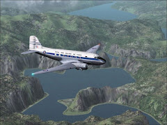
Leg One: I chose a charter flight in a Fokker Jet (my own repaint) but you are welcomed to use anything from a DC-3/4 to 737/727. From Addis we’ll take a flight, just under 800 miles in to Entebbe, Uganda. [Pictures One and Two ]
Airport: ............... Kampala
Name: .................. Entebbe Intl
Country: ............... Uganda
Elevation: ............. 3782 Feet / 1153 Meters
IATA: .................. EBB
ICAO: .................. HUEN
Latitude: .............. 0°2' 32" N
Longitude: ............. 32°26' 36" E
Runway 1 Length: ....... 12000 Feet / 3658 Meters
Runway 2 Length: ....... 7900 Feet / 2408 Meters
I really don’t have a lot to tell you about Entebbe because when we were there (for a couple of hours) the Supreme-Commander-General, Mr. President, His Highness, Idi Amin Dada, wouldn’t allow us off the airplane. But, there is some interesting history about Entebbe: http://news.bbc.co.uk/onthisday/hi/dates/stories/july/4/newsid_2786000/2786967.stm http://www.us-israel.org/jsource/Terrorism/entebbe1.html http://www.claremont.org/writings/precepts/20010704palm.html
I’d also recommend the 70’s-era movie staring Charles Bronson called “Raid on Entebbe.” For those that may want to try out the Club’s (or your favorite) C-130 Hercules you will be pretty accurate to what the Israeli Special forces used on their Raid of 1976. All I remember is that it was HOT, sitting out in the bright sun in that old DC-6, out on the tarmac! (Oh, and that the airport buildings looked strangely pink?)
Leg Two: Okay, moving on. After your stopover at Entebbe you can continue on southwestward (or directly across Lake Victoria) in to Goma, Zaire/Congo. This flight is less then 300 miles so a Regional Turboprop or other twin could be a good choice (unless you’d like to stay in the DC-3). I chose to leave my Fokker at Entebbe and take a Fairchild Metroliner (another one of my own repaints), into Goma. [Pictures Three and Four ]
Airport: ............... Goma
Name: .................. Goma
Country: ............... Zaire
Elevation: ............. 5089 Feet / 1551 Meters
IATA: .................. GOM
ICAO: .................. FZNA
Latitude: .............. 1°40' 14" S
Longitude: ............. 29°14' 18" E
Runway 1 Length: ....... 6545 Feet / 1995 Meters

There is high terrain north of the city so depending on weather and visibility you will either want to make a VOR/DME step-down approach from the south or, cross the VOR northbound at about 8,000 ft MSL and hope to be visual enough for a pattern approach from the north. For my approach, I know this area pretty well so I shot the gap between a couple hills, and made a direct north approach. My line-up after the last mountain was a bit late but shockingly, I greased the landing just after the “18” and right in the middle!
In real life I spent a long weekend in Goma, and LOVED it. We were so warmly accepted and hosted in this city that I still cherish the place as one of my favorites in all of Africa. I still have a cassette tape of the church service there and the sound of the choir in that masonry building with metal roof is incredible – as was the sound of the rain, which fell during the Friday evening meeting! I felt a sense of personal loss a few years ago when Mt. Nyiragongo erupted and flowed right through the city and into Lake Kivu. http://www.eri.u-tokyo.ac.jp/KAZANKYO/n_report/72.pdf
And here is where we shall leave you this month, in Central Africa, under the shadow of great mountains, surrounded by lush forests, in the company of wonderful people! Enjoy.
Optional Flight: For a little extra credit you can look back into the http://www.toomuchfs.com/ “OnTheSide” archives and find my “African Heroes” flight. Then make the 93-mile trip north of Goma into Lubero. For a little fun try limiting visibility and adding in some gusting southerly winds. This time, I just flew the Club’s Twotter using Real-World Weather. [Picture Five] and [Picture Six]